Javakheti Volcanic Lakes Trek
A five-day crossing of the volcanic uplands of southern Georgia, from an Armenian village near Lake Paravani over the Abul-Samsari ridge to Lake Tabatskuri, with three nights of camping, pack horses for the gear and a finale at the cave city of Vardzia.
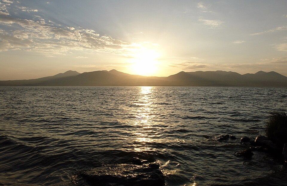 Paravani LakePhoto: Paata Vardanashvili, CC BY 2.0
The Javakheti plateau feels nothing like the Georgia of postcards. At around 2,000 m, it is a wide, treeless land of lava fields, shallow lakes and dormant volcanoes, with villages of Armenian farmers and summer camps of Azerbaijani shepherds. Its spine is the Abul-Samsari range, a line of extinct cones topped by Didi Abuli at about 3,300 m. Cranes, pelicans and geese use the lakes on migration, and in June the meadows turn yellow and purple with flowers. Very few foreign hikers come here, and there are no guesthouses along much of the route.
That is why we run this trek with full support. Pack horses carry tents, food and water, a cook sets up camp each evening, and a 4x4 meets you where tracks allow. The walking is on open grass and old shepherd paths, mostly gentle, but the second trekking day crosses a pass above 3,000 m and the third is long. The route follows the line of the Transcaucasian Trail's Samtskhe-Javakheti section in places, with our own camps and shortcuts. On the last day you leave the plateau for Khertvisi fortress and Vardzia, Queen Tamar's cave monastery, before driving back to Tbilisi.
Highlights
- Lake Paravani, the largest lake in Georgia, and the convent at Poka
- The cyclopean basalt walls of Abuli fortress on the ridge
- Camping by the Levani lakes under the Abul volcano
- The pass on the Samsari ridge and the old caldera beyond it
- Lake Tabatskuri, deep, quiet and ringed by grassland
- Khertvisi and the cave city of Vardzia on the way home
Tour facts
Off-trail walking, a 3,000 m pass and three camp nights rule out travellers with reduced mobility. Lake Paravani, Khertvisi and the lower path at Vardzia can be seen by car on our Borjomi and Vardzia in 2 Days.
Places on this tour
5 places · tap any place to read its guide
- 1Tbilisi to Lake Paravani and an Armenian village
- 2Abuli fortress and the Levani lakes
- 3Over the Samsari ridge to the caldera
- 4Across the plateau to Lake Tabatskuri
- 5Down to Khertvisi and Vardzia, then Tbilisi
Day by day
01Tbilisi to Lake Paravani and an Armenian villageOvernight: Homestay near Lake Paravani
Drive south-west out of Tbilisi to Tsalka and up onto the plateau. The land opens out into wide pastures with stone villages and haystacks stacked for the long winter. At Lake Paravani, about 2,070 m above sea level, stop at Poka, where the nuns of St Nino's convent make cheese and jam that you can buy. Continue to Gandzani or a neighbouring Armenian village at the foot of the Abul range. Your hosts serve a home-cooked dinner, and the guide checks gear and introduces the horsemen who will meet you in the morning.
02Abuli fortress and the Levani lakesOvernight: Tents by the Levani lakes
A 4x4 takes you to the end of the village track to save some road walking. From there you climb grassy slopes to Abuli fortress, a ring of enormous basalt blocks dated by archaeologists to the last centuries BC. The view takes in Paravani, the Armenian border hills and the cone of Didi Abuli. Carry on north along the flank of the ridge across lava fields and flower meadows to the Levani lakes. The horses arrive with the camp, and dinner is cooked as the light fades over the plateau.
03Over the Samsari ridge to the calderaOvernight: Tents in the Samsari caldera
Today you cross the backbone of the range. The path climbs steadily over volcanic gravel to a pass at roughly 3,090 m on the Samsari ridge, the high point of the trek. Snow patches can last here into July. On the far side you descend into the wide bowl of the Samsari caldera, the remains of a collapsed volcano, where a small lake makes a good camp. Fit hikers who start early can add the side trip to the summit of Didi Abuli, about 3,300 m, with the guide and a separate horse plan.
04Across the plateau to Lake TabatskuriOvernight: Tents by Lake Tabatskuri
The longest walking day, but the gradient is kind. Leave the caldera and head north over rolling uplands where shepherd families spend the summer with their flocks and dogs; your guide will keep the dogs at a distance. Streams dry up by late summer, so the horses carry water. In the afternoon Lake Tabatskuri comes into view, deep blue below grassy hills at about 1,990 m. Pitch the last camp near the shore and enjoy a final dinner from the camp kitchen, with a fire if the wind allows.
05Down to Khertvisi and Vardzia, then Tbilisi
Say goodbye to the horsemen after breakfast. A 4x4 takes the dirt road off the plateau to Akhalkalaki and down the gorge of the Paravani river to Khertvisi, whose walls crown a crag at a river junction. A few kilometres on is Vardzia, where in the late 12th century monks and masons cut a town of churches, cells and storerooms into the cliff. Spend about two hours exploring it with your guide. After a late lunch beside the Mtkvari, the car takes you back to Tbilisi through Akhaltsikhe and Borjomi, arriving in the evening. We can book a night near Vardzia instead if you prefer to break the drive.
Prices
Price per person for a private tour, by the size of your group. Sample prices
| Group size | Per person | Whole group |
|---|---|---|
| Solo traveller | $2,280 | $2,280 |
| 2 travellers | $1,380 | $2,760 |
| 3-4 travellers | $1,105 | from $3,315 |
| 5-8 travellers | $910 | from $4,550 |
| 9-15 travellers | $760 | from $6,840 |
Room and children
- Single room supplement: $120
- Recommended from age 12; ages 12-17 pay 85% of the adult price.
- Prices change with hotel level and season; your quote is final.
Popular add-ons
- Riding horse for the trek$180
- Extra night near Vardzia with dinner and breakfast$75
- Sleeping bag rental (to about -5 °C)$25
What's included
- Car and driver for the whole trip, switching to a 4x4 on the rough plateau tracks
- Trekking guide in your language for all five days
- Horses and their handlers to carry the camp, drinking water and your main bag
- One homestay night and three camp nights with two-person tents, mats, mess tent and camp cook
- Every meal on the trip, starting with the first day's lunch and ending with lunch on the last
- Vardzia entrance ticket
- Emergency kit: first aid and a satellite device with the guide
- Sleeping bag (we can rent one)
- A riding horse, which can be added
- An extra night near Vardzia to break the last day's drive
- Tips for guide, cook, horsemen and driver
- Insurance including mountain evacuation (Georgia has made health cover mandatory for foreign visitors as of 1 January 2026)
Good to know
Who it's for
- Hikers who have done the famous Caucasus treks and want somewhere almost nobody walks
- Birdwatchers and flower lovers drawn to high-altitude lakes and meadows
- Travellers interested in Georgia's Armenian communities and shepherd life
- People who enjoy camping when the horses and a cook do the hard work
Prefer a bed and a car? Borjomi and Vardzia in 2 Days drives past Paravani and stops at Vardzia without any camping.
What to bring
- A bag rated to around -5 °C, because the plateau freezes at night even in August
- A windproof jacket and gloves for the open ridge
- Sun hat, sunglasses and strong sun cream, since there is no shade at all
- Hiking boots with good soles for loose volcanic gravel
- A water filter or purifying tablets as a backup
- Passport, since the plateau lies near the Armenian and Turkish borders
- There is little or no phone signal between Abuli and Lake Tabatskuri; the guide carries a satellite communicator.
- Thunderstorms build over the ridge on summer afternoons, so walking days start early.
- Shepherd dogs guard the flocks. Stay with the guide and do not approach them.
- The last day is long by car. An extra night near Vardzia is available as an add-on.
Walking days in numbers
| Day | Distance | Up | Down | Hours | Highest point |
|---|---|---|---|---|---|
| 2 | 16 km | +1,000 m | −450 m | 6-7 | 2,700 m |
| 3 | 15 km | +600 m | −650 m | 6-7 | 3,090 m |
| 4 | 22 km | +300 m | −800 m | 7-8 | 2,750 m |
Guest reviews
Questions about this tour
Why is this trek rated hard if the slopes are gentle?
Because it crosses a pass above 3,000 m, includes a 22 km day and spends three nights camping far from roads and phone signal. The ground itself is mostly easy grass and gravel.
What if the Samsari pass is snowbound?
Outside July to mid-September, or after a cold spell, we take a lower route along the shores of Paravani and over the plateau instead, which keeps the lakes and the camps.
Who lives on the plateau?
The villages around Paravani and Ninotsminda are mostly Armenian, and in summer Azerbaijani shepherds bring flocks up to the high pastures. Russian and Armenian are as useful as Georgian here; your guide translates.
Is there drinking water on the route?
The lakes are reliable but need filtering, and the side streams can dry up by late August. The horses carry water, and the cook boils or filters everything.
Can I skip Vardzia?
Yes. The 4x4 can take you from Tabatskuri straight to Bakuriani or Borjomi, which shortens the last day.