Ushba Glacier Hike from Mazeri
A long out-and-back day from Mazeri to the moraine below the Ushba Glacier, passing the 120 m Shdugra waterfall: about 17 km and 1,050 m of ascent return, with the 4,710 m north face of Ushba overhead for the final hours.
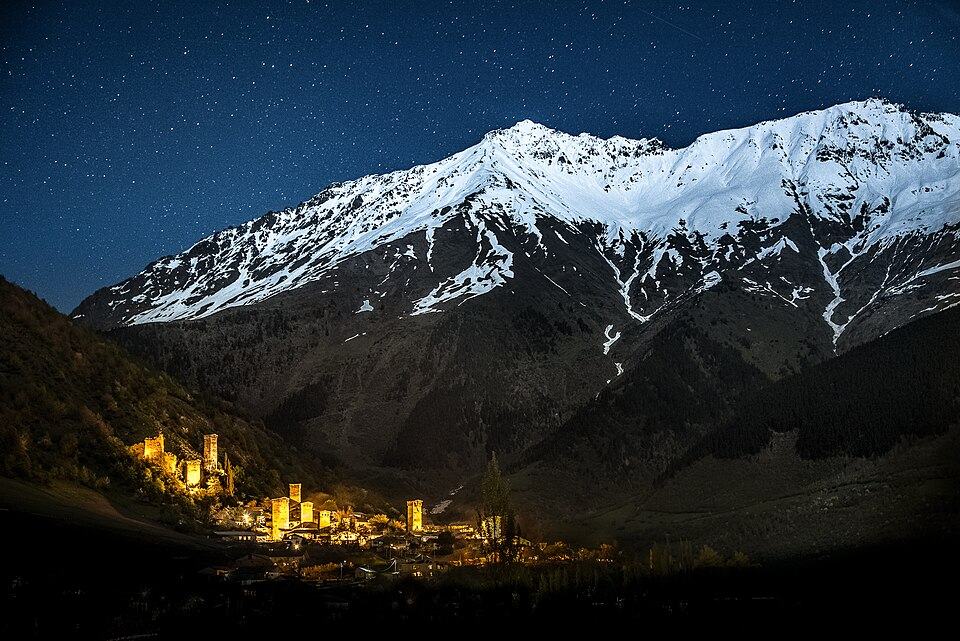 MestiaPhoto: Q-lieb-in, CC BY-SA 4.0
Ushba, the twin-horned peak that dominates every view in Upper Svaneti, rises straight above Mazeri at the head of the Becho valley. This hike follows the Dolra stream north from the village into the gorge beneath it, climbs past the Shdugra (Ushba) waterfall and ends on the moraine below the Ushba Glacier, where the ice spills down from the peak's south face.
The first third, to the foot of the waterfall, is an easy forest walk that families do as a half day. Above that the path becomes steeper and rougher: a stream to cross, a steep climb beside the falls and a final pull over moraine boulders. We grade the full route 3, at the upper end of the level because of the length, around 8 hours for most walkers.
Combine it with a night in Mazeri or with the Guli Pass crossing from Mestia, which ends in the same village.
Highlights
- Close views of the south side of Ushba (4,710 m)
- The roughly 120 m Shdugra waterfall
- A quiet valley with few other walkers
- Glacier ice and icefalls from the moraine
Trail facts
Last checked Oct 2026 by the Maspindzeli team. Mountain conditions change: ask us before you go.
Is this right for you?
Three quick questions for a friendly second opinion. Nothing is sent anywhere.
Stage by stage
| Day | From → to | Distance | Up | Down | Hours | Highest |
|---|---|---|---|---|---|---|
| 1 | Mazeri → Base of the Shdugra waterfall | 3 km | +250 m | −0 m | 1-1.5 h | 1,900 m |
| 1 | Base of the Shdugra waterfall → Top of the waterfall | 3 km | +350 m | −0 m | 1.5-2 h | 2,250 m |
| 1 | Top of the waterfall → Moraine below the Ushba Glacier | 2.5 km | +450 m | −0 m | 1.5-2 h | 2,450 m |
| 1 | Moraine viewpoint → Mazeri | 8.5 km | +0 m | −1,050 m | 3-3.5 h | 2,450 m |
01Mazeri to the foot of the Shdugra waterfallMazeri → Base of the Shdugra waterfall · 3 km · 1-1.5 h
From the upper end of the village, follow the track up the Dolra valley and into mixed forest. The border police post sits along this stretch; keep your passport handy. The path is easy and well trodden, ending in a clearing below the falls, where spray drifts across the rocks.
01Climb beside the waterfallBase of the Shdugra waterfall → Top of the waterfall · 3 km · 1.5-2 h
Cross the stream (shin deep in summer, more in the morning after rain) and climb the steep, rooty path on the side of the gorge. The gradient is relentless for about an hour. At the lip of the falls the valley opens and Ushba fills the skyline.
01Up the moraine to the glacier viewpointTop of the waterfall → Moraine below the Ushba Glacier · 2.5 km · 1.5-2 h
The trail fades into cairns over grass and then loose moraine. Pick the safest line toward the crest of the lateral moraine and stop where you can see the ice fall and the lower glacier. Do not go out onto the glacier itself or climb the unstable moraine walls.
01Return to MazeriMoraine viewpoint → Mazeri · 8.5 km · 3-3.5 h
Descend the same way. The section beside the waterfall is the trickiest going down: wet roots and polished rock, so slow down and use poles. Re-cross the stream with care, as it is higher in the afternoon.
Practical information
Getting there
Mazeri is about 25 km west of Mestia via the Becho turn-off, around 45 minutes by car. In 2026 a taxi from Mestia runs to roughly 70 to 100 GEL one way for the whole car (about $26 to $37); having the driver wait all day pushes it to about 150 to 200 GEL, or $55 to $75. Better still, sleep in one of the Mazeri guesthouses (about 90 to 120 GEL, $33 to $45, per person with dinner and breakfast) and start at first light.
Getting back
Walk back to Mazeri by the same path and call or pre-book a car to Mestia. There is no public transport in the Becho valley, and few cars pass after 17:00.
Water
Fill up in Mazeri. The Dolra side streams on the lower path are drinkable after filtering; above the waterfall the water is glacial and silty. Carry at least 1.5 litres and a filter or tablets.
Phone signal
Fine in Mazeri. Weak from the waterfall upward and usually absent in the deep upper valley below the glacier, so download the route offline.
Nearest help
Dial 112. Mestia's hospital is about 45 minutes by car from Mazeri, with Zugdidi a further 3 hours. The border police post on the route can relay a call if you have no signal.
Permits
No permit is required for this walk, but the upper Becho valley lies close to the Russian border and the path passes a Georgian border police post. Carry your passport and show it if asked. Do not continue beyond the glacier viewpoint toward the frontier ridge.
Gear and safety
What to bring
- Hiking boots with ankle support for the moraine
- Trekking poles
- Sandals or a towel for the stream if you prefer to wade barefoot
- Waterproof layer: spray from the falls and afternoon showers
- Warm jacket for the cold air below the ice
- Passport
- Water filter and 1.5 litres of water
Stay safe
- Start by 08:00. Stream levels rise through the afternoon, and you do not want to cross late.
- Stay off the ice and away from the foot of the moraine walls, where rockfall is frequent.
- In fog the upper moraine has no clear path; turn back at the top of the waterfall if visibility is poor.
- Keep to the path and do not wander toward the border ridge; follow any instructions from the border police.
- Half day: walk only as far as the plunge pool of the falls and return, roughly 6 km with 250 m of climbing, 2.5 to 3 hours.
- Waterfall top: turn round at the lip of the falls, some 12 km in total with 600 m of gain, 5 to 6 hours.
- Arrive on foot from Mestia over the Guli Pass, sleep in Mazeri and walk to the glacier the next day.
- Mazeri to the Becho Pass or toward Meshkhol are longer days for experienced, well-acclimatised walkers; take a local guide.
Emergency number in Georgia: 112. Tell your guesthouse your plan before you set off.
Places on and near the route
Tours that include this trail
Ushba Glacier Hike from Mazeri: FAQ
How long is the hike from Mazeri to the Ushba Glacier?
About 17 km return with roughly 1,050 m of ascent; most hikers take 7 to 9 hours including stops.
Do I need a permit to hike to the Ushba Glacier?
No permit, but the route passes a border police post near the Russian frontier, so carry your passport.
Can I see Ushba without the full hike?
Yes. Ushba is visible from Mazeri itself, and the shorter walk to the foot of the Shdugra waterfall gives good views in about 3 hours return.
Last checked Oct 2026 by the Maspindzeli team. Mountain conditions change: ask us before you go.