Tusheti to Khevsureti Trek via Atsunta
A fully supported crossing of the eastern Greater Caucasus from the tower villages of Tusheti to the fortress village of Shatili in Khevsureti, about 85 km on foot over six walking days, with horses carrying the camp and a guide who knows the border-zone formalities.
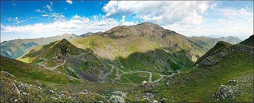 Abano PassPhoto: Chaoseli, CC BY-SA 4.0
Tusheti and Khevsureti sit side by side on the map, yet no road joins them. To get from one to the other by car you would drive back down to the lowlands and up again, a detour of a full day. On foot the link is the Atsunta Pass, a high saddle of scree and late snow at roughly 3,430 m that has been used by shepherds and traders for centuries. This trek follows that old route: from Omalo along the Pirikiti Alazani past Dartlo and Parsma to Girevi, the last inhabited place in the valley, then up through summer pastures to the pass and down the Andaki and Argun valleys to the stone towers of Mutso and Shatili.
We run it as a private trip on the dates you choose, for one hiker or a larger party. Pack horses and their horsemen carry tents, food and your main bag, so you walk with a day pack. A camp cook prepares hot breakfasts and dinners on the four nights under canvas, and the other nights are spent in family guesthouses. The trail crosses a border zone near Russia, so the guide signs everyone in at the border police post in Girevi and carries the permit through the checkpoint on the Khevsureti side. Expect long days, cold mornings, two or three river fords and almost no phone signal between Dartlo and Mutso.
Highlights
- The Abano Pass road into Tusheti, one of the most dramatic drives in the Caucasus
- Dartlo and Parsma, slate-roofed tower villages along the Pirikiti Alazani
- Crossing the Atsunta Pass at about 3,430 m with horses and a mountain guide
- Four nights in tents by streams and high meadows, with a cook in camp
- The ruined tower settlement of Mutso on its crag above the Andaki
- Shatili, a medieval fortress village built as one huddle of stone houses
Tour facts
Long trail days, a high pass, river fords and nights in tents make this trek unsuitable for travellers with reduced mobility. Our Tusheti 4x4 Adventure reaches the same tower villages mainly by vehicle.
Places on this tour
7 places · tap any place to read its guide
- 1Tbilisi to Omalo over the Abano Pass
- 2
- 3Parsma and Girevi, the end of the road
- 4Up the valley to the foot of the pass
- 5Over the Atsunta Pass into Khevsureti
- 6Ardoti and the towers of Mutso
- 7
- 8Datvisjvari Pass and back to Tbilisi
Day by day
01Tbilisi to Omalo over the Abano PassOvernight: Omalo
Your guide and a 4x4 driver pick you up at 7 am. The first part is easy tarmac east through Kakheti to Pshaveli, at the foot of the mountains. From there the road turns to gravel and climbs in tight bends to a high saddle, the Abano Pass (around 2,850 m), and drops into Tusheti. Allow three to four hours for this last 70 km or so, with stops for the views and for your stomach. You arrive in Omalo, the main village of the region, in the late afternoon. If there is light left, walk up to the restored Keselo towers above Upper Omalo. Dinner is at the guesthouse, often with Tushetian guda cheese and khinkali, followed by a briefing on the route.
02Down to the river and up to DartloOvernight: Dartlo
A gentle first day to loosen the legs. The path leaves Omalo and descends through pine and birch to the Pirikiti Alazani, then follows the river upstream on a farm track with several short climbs. Your bags travel on the horses, which meet you in Dartlo. Dartlo is one of the best preserved villages in Tusheti: towers, stone houses with wooden balconies and an open-air council place where elders once judged disputes. In the afternoon you can climb to the abandoned hamlet of Kvavlo above the village for a view down the valley, or simply rest on the guesthouse terrace.
03Parsma and Girevi, the end of the roadOvernight: Tents near Girevi
Today you head deeper into the Pirikiti valley, where the villages grow smaller and the herds larger. You pass Chesho and walk under the towers of Parsma, which cling to a slope above the river. The track crosses side streams that can be fast after rain, and the horses carry anyone who prefers dry feet. By mid-afternoon you reach Girevi, a scatter of houses and a border police post. Your guide registers the group and your passports there. The crew pitches the first camp in a meadow near the village, and the cook serves dinner in the mess tent.
04Up the valley to the foot of the passOvernight: Tents below the Atsunta Pass
Leave the last houses behind and follow the young river towards its source. The path winds through high pastures where Tush shepherds graze sheep all summer, and you may be offered fresh cheese at a summer hut. The valley narrows and the peaks of the main ridge close in. Camp tonight is in the Kvakhidi area at roughly 2,600 m, the last good level ground before the climb. Use the afternoon to rest, drink plenty of water and sort your layers for tomorrow, because the morning starts cold and early.
05Over the Atsunta Pass into KhevsuretiOvernight: Tents on the Khidotani side
This is the big day. Set off by 6 am and climb steadily on grass, then loose scree and, in most summers, a snowfield near the top. The guide sets the pace and the horsemen lead the animals on their own line. From the saddle at about 3,430 m you look back over Tusheti and forward into the deep valleys of Khevsureti. The descent is long and steep, with stony zigzags and a couple of stream crossings where the horses help. Camp is on the Khidotani side, near the checkpoint where the border police look at the permit from Girevi.
06Ardoti and the towers of MutsoOvernight: Tents near Mutso
An easier day down the Andaki valley, through birch woods and past hay meadows. You pass the near-empty village of Ardoti, where only a few families spend the summer. In the afternoon Mutso appears: a cluster of defensive towers and houses stacked on a rock spur high above the river, partly rebuilt in recent years. Climb up to the ruins with your guide and look at the stone burial houses on the slope below, where by tradition plague victims went to die. The last camp is pitched by the river near the village, and the crew prepares a farewell dinner.
07Along the Argun to ShatiliOvernight: Shatili
The final walking stage follows the Argun downstream on a dirt road, so it is fast and easy. The horsemen say goodbye here and set off back towards Tusheti. Shatili comes into view at a bend in the river: about sixty stone houses and towers joined into a single fortress, where families once lived through winter sieges. Spend the afternoon exploring its lanes, roofs and passages, and visit the small local museum if it is open. Tonight you sleep in a guesthouse inside or beside the old village, with a hot shower at last.
08Datvisjvari Pass and back to Tbilisi
A 4x4 collects you after breakfast. The road climbs out of the Argun valley to the Datvisjvari Pass at about 2,680 m, then twists down to Barisakho and the Aragvi. Further south it becomes tarmac and joins the Georgian Military Highway near Zhinvali. A stop at Ananuri fortress breaks the journey and you are back in the capital by late afternoon. If you fly the same night, allow a buffer: the Datvisjvari road is unpaved and can close for a few hours after heavy rain.
Prices
Price per person for a private tour, by the size of your group. Sample prices
| Group size | Per person | Whole group |
|---|---|---|
| Solo traveller | $3,590 | $3,590 |
| 2 travellers | $2,175 | $4,350 |
| 3-4 travellers | $1,740 | from $5,220 |
| 5-8 travellers | $1,435 | from $7,175 |
| 9-15 travellers | $1,195 | from $10,755 |
Room and children
- Single room supplement: $210
- Recommended from age 14; ages 14-17 pay 85% of the adult price.
- Prices change with hotel level and season; your quote is final.
Popular add-ons
- Riding horse for the whole trek$320
- Sleeping bag rental (to about -5 °C)$35
- Extra night in Tbilisi with breakfast$90
- Tbilisi airport transfer (car, 1-3 people)$30
What's included
- 4x4 transfer from Tbilisi to Omalo and from Shatili back to Tbilisi
- Mountain guide in your language for all eight days, with an assistant guide for larger groups
- Pack horses and horsemen from Omalo to Mutso for camp gear, food and each hiker's main bag (weight limit about 15 kg)
- Three guesthouse nights (Omalo, Dartlo, Shatili) and four camp nights
- Two-person tents, sleeping mats, mess tent, camp kitchen and a camp cook
- Full board from the first lunch to the final one on day 8, with packed lunches on trail days
- Border police registration in Girevi, arranged by the guide
- A satellite messenger and a full first-aid kit in the guide's pack
- Sleeping bag (rentals available on request)
- A riding horse for the whole trek (available as an add-on)
- Drinks other than water and tea, and snacks bought in villages
- Tips for guide, cook, horsemen and drivers
- Insurance that covers trekking up to 3,500 m and mountain evacuation (since 1 January 2026 every visitor to Georgia must also carry health insurance)
Good to know
Who it's for
- Experienced hill walkers looking for a true point-to-point crossing of the Caucasus
- Hikers who want camping in wild places without carrying a heavy pack
- Travellers curious about the mountain cultures of the Tush and Khevsur peoples
- Small private parties of friends or family who want their own guide, cook and horses
If you would rather sleep in a bed every night and keep the days shorter, our Kazbegi Hiking Week gives you big mountain views from one comfortable base.
What to bring
- Broken-in waterproof hiking boots with good grip for scree and wet grass
- A three-season sleeping bag comfortable to about -5 °C for the camps around 2,500 m
- Trekking poles, which make the long Atsunta descent much easier on the knees
- River sandals or light shoes for the fords
- Your passport for the border police registration in Girevi
- Enough lari in cash for eight days, since there are no ATMs in Tusheti or Khevsureti
- A power bank and a headtorch, as camps have no electricity
- In a normal year vehicles can use the Abano Pass from June into early October, but rain or a landslide can shut it, so keep a spare day before onward travel.
- The trek crosses a border zone near Russia. Every hiker must be registered by name and passport; the guide arranges it.
- Snow can linger on the Atsunta Pass into July. The guide may change the day order or turn back if conditions are unsafe.
- Each hiker's main bag rides on a horse, so keep it near 15 kg and carry a 25-30 litre day pack yourself.
- There is no phone signal for most of days 3 to 6. The guide carries a satellite communicator.
Walking days in numbers
| Day | Distance | Up | Down | Hours | Highest point |
|---|---|---|---|---|---|
| 2 | 12 km | +450 m | −400 m | 4-5 | 2,000 m |
| 3 | 17 km | +550 m | −250 m | 6 | 2,250 m |
| 4 | 15 km | +550 m | −100 m | 5-6 | 2,650 m |
| 5 | 15 km | +900 m | −1,000 m | 8-9 | 3,430 m |
| 6 | 14 km | +250 m | −800 m | 5-6 | 2,450 m |
| 7 | 12 km | +100 m | −450 m | 3-4 | 1,900 m |
Guest reviews
Questions about this tour
How hard is the Atsunta Pass?
It is a high, remote crossing rather than a technical climb. The pass day is 8-9 hours with about 900 m of ascent and 1,000 m of descent on scree and often a short snowfield. The other walking days are 3-6 hours. You need to be a regular hill walker who can manage two or three long days back to back.
Do I need a permit?
Yes. The route runs through a border zone, so every hiker must be registered with the Georgian border police, usually at the post in Girevi. Bring your passport, not a copy. Your guide handles the paperwork and shows the permit on the Khevsureti side.
Can I ride a horse instead of walking?
You can hire a riding horse for some or all of the route. On the steepest parts of the Atsunta descent everyone usually walks and leads the horses, for safety.
Which direction is better?
We usually walk from Tusheti to Khevsureti because the climb to the pass is more gradual from that side. The reverse direction works too, starting in Shatili, if your dates or the road conditions suit it better.
What happens if the pass is closed by weather?
The guide decides on the morning of the crossing. If snow or storms make it unsafe, you wait a day in camp when the schedule allows, or turn back to Girevi and return to Tbilisi by road. Leave a spare day before your flight home if you can.
Is there phone signal or electricity?
Omalo and Shatili have patchy signal and electricity, often from solar panels. Between Dartlo and Mutso expect nothing. The guide carries a satellite communicator for emergencies.